

Herring River Restoration Project
For more information: Herring River Executive Council
The Herring River system is a 1,100-acre tidally-restricted estuary located in the Towns of Wellfleet and Truro, Massachusetts. Prolonged tidal restriction has resulted in severe habitat degradation and nearly complete loss of native tidal wetland habitat. Herring River is listed as an “Impaired Water” under the Clean Water Act, and the Chequessett Neck Road Bridge is a state-designated point source for bacterial contamination.
The Herring River Restoration Project (or “Project”) will re-establish tidal flow to the estuary incrementally using a carefully calibrated adaptive management approach that will balance ecological goals with water level control measures to allow the highest tide range practicable while protecting potentially vulnerable structures on public and private properties, including roads and homes. Tidal flow will be facilitated through replacement of a portion of the existing earthen dike and tidal control structure at Chequessett Neck Road with a new bridge and sluice gate system; construction or alteration of other tidal control structures at the entrances to the Mill Creek and Upper Pole Dike Creek sub-basins; removal of a portion of High Toss Road where it crosses the marsh between the Lower Herring River and Mid-Herring River sub-basins; vegetation and marsh management; and measures to prevent water intrusion impacts to structures on public and private properties. Extensive ongoing modeling, monitoring and analysis will guide Project implementation so that unexpected and/or undesirable responses can be detected early on and addressed with appropriate adaptive management actions. The Project will result in significant improvements in water quality, rare species habitat, fisheries, and recreational opportunities throughout the Herring River floodplain while improving its resiliency and ability to adapt to the effects of climate change. Restored tidal wetlands will significantly reduce greenhouse gas emissions by reclaiming lost carbon storage and reducing methane emissions.
The project proponents are the Town of Wellfleet and U.S. National Park Service (NPS) Cape Cod National Seashore (Seashore). The Town of Wellfleet is owner of most of the water control infrastructure needed to achieve tidal restoration. Likewise, much of the public and private property on which measures to protect structures from potential impacts caused by tidal restoration will occur in the Town of Wellfleet.
The Town of Wellfleet and the Seashore entered into successive memoranda of understanding (MOUs) to study the feasibility of restoration (MOU I in 2005), develop a conceptual restoration plan (MOU II in 2007) and agree to implement the restoration plan (MOU III in 2016). The Town of Wellfleet and Seashore recently entered into a new Memorandum of Understanding (MOU IV) to guide their collaboration.
The MOUs set forth the structure and decision-making process for the Project. MOU IV establishes a Herring River Executive Council consisting of three members from Wellfleet and two from the Seashore. MOU IV also describes a Herring River Technical Team (HRTT), an informal sounding board composed of intergovernmental technical staff to provide technical input for Project-related decisions as necessary or appropriate. Participants in the Technical Team include the Town of Wellfleet, National Park Service, U.S. Fish and Wildlife Service, National Oceanic and Atmospheric Administration, USDA/Natural Resources Conservation Service, and Massachusetts Department of Fish and Game - Division of Ecological Restoration. Project management and coordination support is provided by the non-profit Friends of Herring River (FHR).
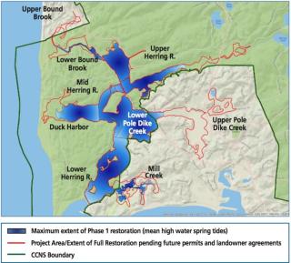
Phase 1 of the Project proposes to restore up to approximately 570 acres of tidal wetlands (Figure 1). Maximum water levels in all areas of the estuary affected by Phase 1 tidal restoration will be kept below elevations that could impact any private structures that are not protected by Phase 1 protection measures.
Future phases of restoration may propose to increase water levels above the maximum water level authorized in Phase 1 and may include increasing/initiating tidal restoration in the Mill Creek and Upper Pole Dike Creek sub-basins. Any future proposals to increase water levels above the maximum water level authorized in Phase 1 will require permit amendments or new permits as well as consent of property owners for site-based mitigation of potential structural impacts.
The Project proposes to use a rigorous form of adaptive management to guide the restoration of tidal flow in the Herring River system. Following adaptive management guidelines, the Project will restore tidal flow incrementally while water quality, vegetation, tide levels, salinity, sediment movement and many other environmental factors are monitored and compared with pre-restoration conditions and expected changes. The configuration of tide gates at the proposed Chequessett Neck Road bridge and water control structure is the primary means of regulating the amount of tidal exchange in Herring River and, therefore, the pace of habitat restoration. The rate of tidal restoration can be slowed, reversed, or increased based on the system response as indicated by monitoring data.